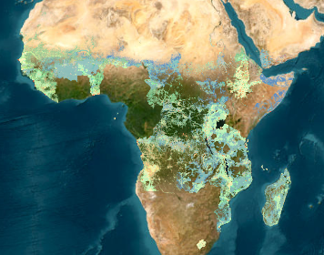
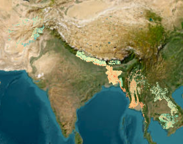
METEOR is a three year project funded by the UK Space Agency to develop innovative application of Earth Observation (EO) technologies to improve understanding of exposure with a specific focus on the countries of Nepal and Tanzania.

The METEOR project consortium is a composed of eight organizations crossing four continents and with expertise spanning from humanitarian aid, to remote sensing, from disaster risk reduction to policy advice.

For more information about the METEOR project please see meteor-project.org. To download level 1 exposure data for individual countries, please see the METEOR project data download page.

If you find this map portal and/or our data useful, please provide feedback via our questionnaire, it should take only a few minutes.

Published maps

Card image cap

Level 1 Exposure for Africa and Arabian Peninsula

Level 1 Exposure for 33 countries in Africa plus Yemen.

exposure

Updated by pslh
on Feb 10, 2023
Card image cap

Level 1 Exposure for continental Asia

Level 1 Exposure data by ImageCat for Afghanistan, Bangladesh, Bhutan, Cambodia, Laos, Myanmar and Nepal

exposure

Updated by pslh
on Feb 10, 2023
Card image cap

Level 1 Exposure data for Pacific region

Level 1 Exposure data for Kiribati, Solomon Islands, East Timor, Tuvalu, Vanuatu

exposure

Updated by pslh
on Feb 10, 2023
Card image cap

Level 1 exposure for Haiti

Level 1 exposure for Haiti 

exposure

Updated by pslh
on Feb 10, 2023
Card image cap

Building Exposure Map of Nepal

Level 3 Exposure data for Nepal by ImageCat

exposure

Updated by pslh
on Feb 10, 2023
Card image cap

Building Exposure Map of Tanzania

Level 3 Exposure Map for Tanzania, by ImageCat

exposure

Updated by pslh
on Feb 10, 2023
Card image cap

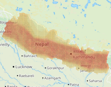
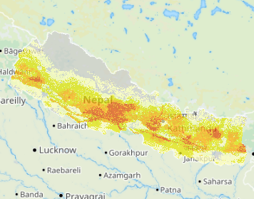
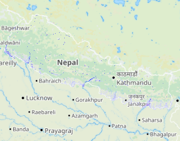
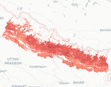
Nepal seismic hazard map

Seismic Hazard map for Nepal.  Peak Ground Acceleration (g), 10% probability of exceedence in 50 years.


hazard earthquake

Updated by pslh
on Feb 10, 2023
Card image cap

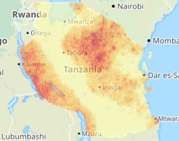
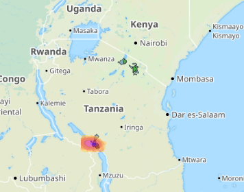
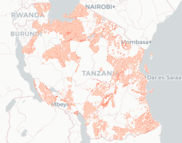
Tanzania Seismic Hazard Map

Seismic Hazard Map showing Peak Ground Acceleration (PGA) in g for a 10% probability of exceedence in 50 years for the country of Tanzania.

This map was produced using the GEM OpenQuake engine using the SSAHARA model produced, please see https://h…

hazard earthquake

Updated by pslh
on Feb 21, 2023
Card image cap

Nepal Landslide Hazard and Susceptibility

Earthquake and rainfall-triggered landslide hazard and susceptibility map for Nepal

hazard landslide

Updated by pslh
on Feb 10, 2023
Card image cap

Tanzania Volcanic Ash Fall, Lahar and PDC basins

Ashfall hazard footprints for Rungwe VEI2 and VEI4 with probable maximum extents for lahar and pyroclastic density currents.

hazard volcanic

Updated by pslh
on Feb 10, 2023
Card image cap

Dar Es Salaam Building Survey by HOT

Humanitarian OpenStreetMap Team building survey data for Dar es Salaam collected by Ramani Huria

Includes OSM attributes along with GEM Taxonomy string.

exposure

Updated by pslh
on Feb 10, 2023
Card image cap

Kathmandu Building Survey by HOT

Humanitarian OpenStreetMap Team building survey data for Dar es Salaam collected by Ramani Huria

Includes OSM attributes along with GEM Taxonomy string.

exposure

Updated by pslh
on Feb 10, 2023
Card image cap

Nepal Flood hazard map

Nepal Flood maps: Fluvial Defended, Undefended and Pluvial for various return periods.

hazard flood

Updated by pslh
on Feb 10, 2023
Card image cap

Tanzania all Flood Hazard Map

Tanzania floods, pluvial, fluvial defended and fluvial undefended for various return periods

hazard flood

Updated by pslh
on Feb 10, 2023
Card image cap

Tanzania Multihazard map

Combined Multihazard index map for Tanzania

hazard

Updated by pslh
on Feb 10, 2023
Card image cap

Nepal Multihazard map

Combined Multihazard index map for Nepal

hazard

Updated by pslh
on Feb 10, 2023